October 4, 2023
Updated January 13, 2025Through efforts from the Federal Highway Administration, the National Cooperative Highway Research Program (NCHRP), the National Association of City Transportation Officials (NACTO) and other organizations at the forefront of transportation project guidance, the number of guidebooks and guidance documents for planning, designing, and implementing pedestrian and bicyclist facilities has blossomed in recent years. This is great news for our profession in general and for the advancement of active transportation projects specifically—but it can be a confusing world to navigate, especially when many of the guidebooks appear to cover very similar topics. How do you know which one to pull off the shelf?
In response to this question, we’ve assembled a list that breaks down 24 major active transportation guidance documents: where they fit in the project lifecycle, what they cover, and how they can be used. Recognizing that these are not exhaustive lists of quality guidance that can be applied to projects, we’ve also included an “Additional Resources” section for each, and welcome suggestions for resources to add!
How We’ve Organized the List
Bikeway Selection Guide? Separated Bike Lane Planning and Design Guide? Urban Bikeway Design Guide? It’s a great problem to have so much guidance to choose from when planning and designing active transportation facilities, but it can be challenging to distinguish between them all, and especially to know when each guide should be consulted.
For the purposes of our list, we’ve simplified the transportation project lifecycle into three main stages: Planning & Prioritization, Preconstruction & Design, and Operations & Maintenance. Here’s what we mean by each.
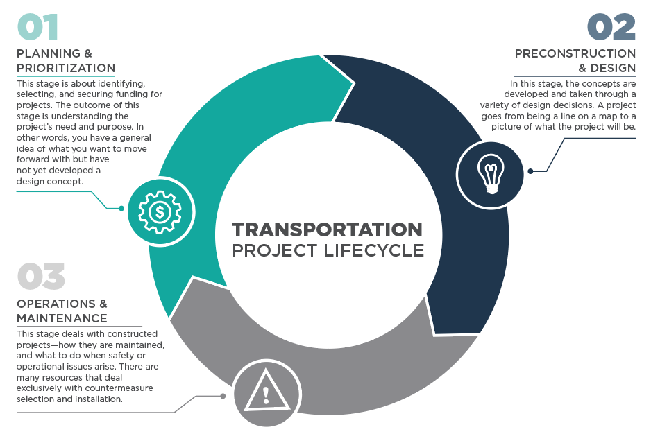
While many guidebooks have relevance in more than one stage, in the following breakdown, we’ve mapped each document to the stage where it’s likely to be most prominently used. Below each list, we’ve provided a summary of each document and how it should be used within that stage.
Pedestrian Guidance Documents
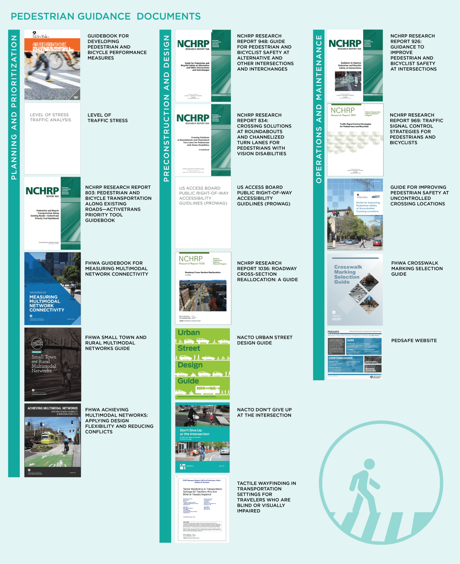
Planning and Prioritization
What is it? A guide that presents a framework and performance measures for quantifying safety, operations, and comfort for people walking and bicycling on transportation facilities.
Suggested usage: This is a planning tool that should be used early on in the process. It helps identify metrics that can be used to evaluate pedestrian and bicyclist facilities.
What is it? A GIS-based method to evaluate the expected level of traffic stress (LTS) for non-motorized users’ experiences on transportation facilities. The pedestrian LTS method is still relatively new in the profession.
Suggested usage: This is a tool to quickly conduct a network analysis of pedestrian facilities. Key outcomes of the assessment are the low-stress network (areas that can be accessed via walking at LTS 1 or 2) as well as high-stress barriers to walking (LTS 3 or 4 facilities).
What is it? A guide designed to assist planners and decision-makers through the project prioritization process for pedestrian and bicyclist projects.
Suggested usage: The guide includes a spreadsheet tool that agencies and communities can use to identify goals, develop weights, and prioritize projects according to goals and objectives.
What is it? Guidance on measuring pedestrian and bicyclist network connectivity and incorporating connectivity analysis into the transportation planning process.
Suggested usage: This guide helps apply a connectivity lens-that is, who can access what destinations-for understanding how a street network serves people walking and bicycling. It is helpful in helping identify priority improvements to the network and understanding impacts of projects.
What is it? A design resource and idea book for rural and small town communities seeking to achieve safe, comfortable, and active travel for people of all ages and abilities.
Suggested usage: Much of the guidance and precedents for high quality walking and bicycling infrastructure comes from urban locations and can feel incompatible with less dense places. This guide offers ideas and context-sensitive solutions for rural and small town communities.
What is it? A guide that highlights ways to apply design flexibility while focusing on improving safety for people walking and bicycling.
Suggested usage: The guide includes 24 design topics, 12 of which are focused on applying flexibility in design treatments, and 12 of which are focused on reducing conflicts between modes. The information in the guide can help planners, designers, and policy makers understand options for improving safety and eliminate perceived barriers to implementation.
Preconstruction and Design
What is it? A guide for improving non-motorized user safety at intersections, including alternative intersections and interchanges (A.I.I.). It presents a quantitative analysis method built around 20 design flags, which highlight design characteristics that impact safety and quality of service for people walking and bicycling.
Suggested usage: While the guide covers planning, design, and operational treatments, its primary intent is to be applied in the preliminary design stage, considering pedestrian and bicyclist performance early before design decisions preclude the integration of quality pedestrian/bicyclist facilities. It can be used as a comparison tool when selecting between various intersection alternatives at all intersection types (not just A.I.I.s) in an Intersection Control Evaluation (ICE) process.
What is it? An assessment tool specific to accessibility. Roundabouts and channelized turn lanes (CTL) are difficult to navigate for pedestrians with vision disabilities; this guidebook describes how to evaluate and retrofit a roundabout or CTL for accessibility, including both wayfinding tasks and pedestrian crossings.
Suggested usage: Refer to this guide early in the design process so that the needs of pedestrians with vision disabilities are taken into account. The method is also formally integrated into the new Roundabout Guide. It can be used for applications beyond roundabouts as well, with particular focus on CTLs. It can readily be applied to support an accessibility audit of an existing intersection.
What is it? Guidelines developed to support the Americans with Disabilities Act (ADA) and the Architectural Barriers Act (ABA) that address access to sidewalks and streets, crosswalks, curb ramps, pedestrian signals, on-street parking, and other components of public rights-of-way. After more than 21 years of research and revision, the final rule went into effect on September 7, 2023.
Suggested usage: PROWAG is legal interpretation of the ADA, used to specify minimum accessibility standards for public right of way. While it comes into play at all three stages, it is most applicable here in the design stage.
What is it? A six-step framework that helps practitioners evaluate tradeoffs, considering outcomes related to transportation, livability, economic and environmental health, equity, and other concerns in cross-sectional reallocation projects (also includes potential road diets).
Suggested usage: While NCHRP 1036 should be used throughout the project development process, its primary use is here in the design stage as a performance-based approach to reallocating cross-sections and daylighting the safety implications of design and cross-section decisions to all users.
The pre-publication draft can be found here.
What is it? A transportation design resource for all aspects of street design, from building front to building front. Rather than focusing on a single mode of transportation, the USDG covers the many ways people and communities interact with public spaces.
Suggested usage: This guide brings a new perspective to street design and can help planners and designers think creatively about their streets. It includes detailed design guidance for streets and sidewalks, and emphasizes designing for safety and traffic calming. It covers street cross sections and crossings to help designers use street space safely and efficiently.
What is it? An expansion of the NACTO Urban Bikeway Design Guide, with additional detailed guidance on intersection design treatments that reduce vehicle-bike and vehicle-pedestrian conflicts. The guidance covers protected bike intersections, dedicated bike intersections, and minor street crossings, as well as signalization strategies to reduce conflicts and increase comfort and safety.
Suggested usage: This is a resource for designing intersections to be safe and comfortable for people walking and bicycling. It covers protected intersections, major and minor street crossings, and signal phasing strategies. It also includes a toolkit for intersection design strategies applicable to a variety of contexts, construction types, and applications.
What is it? This resource provides strategies for implementing tactile wayfinding elements, such as detectable warning surfaces (DWS), tactile directional indicators (TDI), and tactile warning delineators (TWD), to improve navigation for pedestrians who are blind or visually impaired. It includes design recommendations and considerations for integrating tactile systems into transportation facilities at transit stations, street crossings, and on urban plazas.
Suggested usage: Apply this guidance early in the planning and prioritization process, and throughout preconstruction and design, to ensure inclusive design and accessibility for all pedestrians, especially those with visual impairments.
Operations and Maintenance
What is it? Guidance on how to create safe crossings and select the best safety measures for the intersections, based on site conditions.
Suggested usage: This report is useful for selecting countermeasures at intersections that have demonstrated safety issues. It can be used for systemic changes, not just specific sites.
What is it? A report that provides performance measures for considering pedestrian delay as part of an intersection analysis and 28 unique treatments to make intersections more friendly for people walking and bicycling.
Suggested usage: As with NCHRP 926, this report is meant to be used to analyze intersections that are already built and operating. While it is best to integrate pedestrians and bicyclists into the initial design, the guide offers treatments to improve safety and accessibility for people on bike and on foot.
What is it? An official FHWA publication with guidance on countermeasure selection. This is a broad, context-sensitive guide designed to reduce pedestrian fatalities and injuries at uncontrolled crossing locations.
Suggested usage: This guide can be used to identify priority locations for implementing safety countermeasures, as well as what those countermeasures should be, based on road conditions, crash causes, and pedestrian safety issues.
What is it? A guide developed through researching the effect of crosswalk markings on driver yielding behavior.
Suggested usage: This guide is meant to be used as a decision support tool for selecting crosswalk marking designs. It includes considerations for materials, maintenance, and costs. It specifically points to the significant relationship between vehicle speeds and driver yielding to pedestrians.
What is it? A website commissioned by FHWA that provides general information on creating safe conditions for people who walk, along with a list of countermeasures and tools for selecting which countermeasures are appropriate for the intersection at hand.
Suggested usage: This can be a handy resource for the evaluation and selection of countermeasures. Online tools provide the user with a list of possible engineering, education, or enforcement treatments to improve pedestrian safety and/or mobility based on user input about a specific location.
Additional Resources on Pedestrian Facilities and Crossings
- ITE Designing Walkable Urban Thoroughfares: A Context Sensitive Approach (2010)
- AASHTO Guide for the Planning, Design, and Operations of Pedestrian Facilities (2004)
- NACTO Transit Street Design Guide
- NACTO Urban Street Design Guide
- AASHTO Green Book – A Policy on Geometric Design of Highways and Streets, 7th Edition
- FHWA Guidebook for Measuring Multimodal Network Connectivity (2018)
- Safety Effects of Marked Versus Unmarked Crosswalks at Uncontrolled Location Final Report and Recommended Guidelines, FHWA Publication Number: HRT-04-100 (2005)
- TCRP Report 112/NCHRP Report 562: Improving Pedestrian Safety at Unsignalized Crossings (2006)
- Manual on Uniform Traffic Control Devices for Streets and Highways (2009)
- PBOT PedPDX: Portland’s Citywide Pedestrian Plan (2019)
- Washington DOT Pedestrian Facilities Guidebook (1997)
- Ottawa Protected Intersection Design Guide (2021)
Bicyclist Guidance Documents
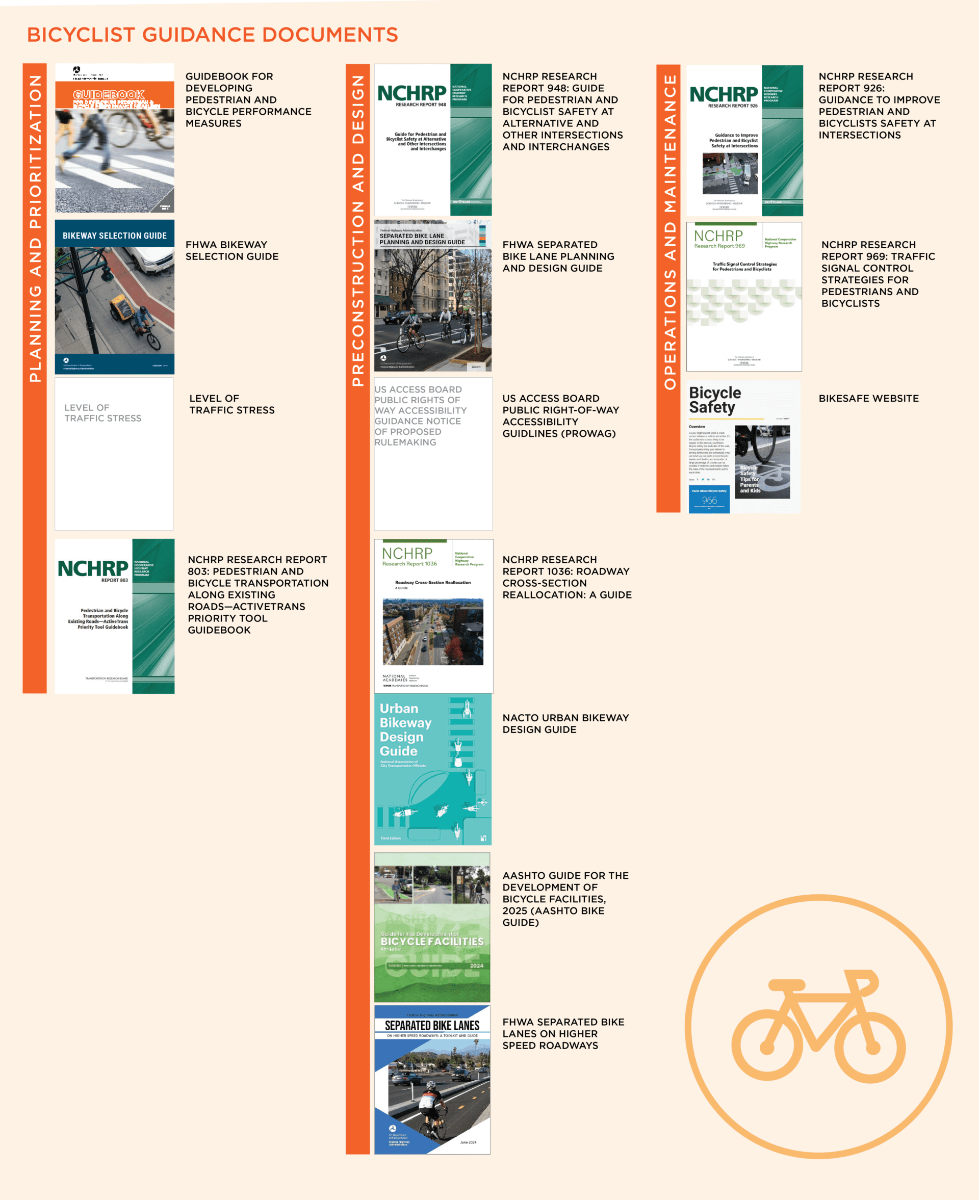
Planning and Prioritization
What is it? A guide that presents a framework and performance measures for quantifying safety, operations, and comfort for people walking and bicycling on transportation facilities.
Suggested usage: This is a planning tool that should be used early on in the process. It helps identify metrics that can be used to evaluate pedestrian and bicyclist facilities.
What is it? Resource to help transportation practitioners consider and make informed trade-off decisions relating to the selection of bikeway types, including on-street, separated, and exclusive bicycling facilities.
Suggested usage: Use this at the very beginning of a design project-when a bicyclist facility is nothing but a line on a map from a multimodal plan. This guide helps you figure out what type of facility you need and incorporate that facility type (and associated right-of-way needs and cost estimates) in the planning and project prioritization process.
What is it? A GIS-based method to evaluate the expected level of traffic stress (LTS) non-motorized users experience on transportation facilities. The bicyclist LTS method is well established in the profession.
Suggested usage: This is a tool to quickly conduct a network analysis of bicyclist facilities. Key outcomes of the assessment are the low-stress network (areas that can be accessed via bicycling at LTS 1 or 2) as well as high-stress barriers to biking (LTS 3 or 4 facilities).
What is it? A guide designed to assist planners and decision-makers through the project prioritization process for pedestrian and bicyclist projects.
Suggested usage: The guide includes a spreadsheet tool which agencies and communities can use to identify goals, develop weights, and prioritize projects according to goals and objectives.
Preconstruction and Design
What is it? A guide for improving non-motorized user safety at intersections, including alternative intersections and interchanges (A.I.I.). It presents a quantitative analysis method built around 20 design flags, which highlight design characteristics that impact safety and quality of service for people walking and bicycling.
Suggested usage: While the guide covers planning, design, and operational treatments, its primary intent is to be applied in the preliminary design stage, considering pedestrian and bicyclist performance early before design decisions preclude the integration of quality pedestrian and bicycle facilities. It can be used as a comparison tool when selecting between various intersection alternatives at all intersection types (not just A.I.I.s) in an Intersection Control Evaluation (ICE) process.
What is it? A resource that spans the planning and design of separated bike lanes and provides use cases, design details, and implementation examples for different types of bicycling facilities.
Suggested usage: While also relevant in the planning stage, this guidebook is very useful in the design stage. It begins with the assumption that a separate bicycle lane is needed and walks practitioners through a four-step design process to establish directional and width criteria, select forms of separation, identity midblock design challenges and solutions, and develop the intersection design.
What is it? A six-step framework that helps practitioners evaluate tradeoffs, considering outcomes related to transportation, livability, economic and environmental health, equity, and other concerns in cross-sectional reallocation projects (also includes potential road diets).
Suggested usage: While NCHRP 1036 should be used throughout the project development process, its primary use is here in the design stage as a performance-based approach to reallocating cross-sections and daylighting the safety implications of design and cross-section decisions to all users.
The pre-publication draft can be found here.
What is it? A primary resource for bikeway design in urban environments. This guide is created by city transportation officials to spread best practices and innovation among its members and beyond.
Suggested usage: This guide provides design guidance and contextual information for building bicycle facilities in urban environments. It is a great resource for new or innovative designs that may not be covered in older design guides. It also includes many photos and examples of built projects around the country.
What is it? The 2025 AASHTO Bike Guide is the latest resource for designing bicycle facilities, offering best practices for creating bike-friendly infrastructure. It provides a detailed technical resource for planners and engineers working on projects like bike lanes, shared-use paths, and intersection designs.
Suggested usage: Refer to this guide during the design phase of bicycle facility projects to follow the latest best practices and to promote safe, comfortable bike infrastructure. The guide also covers planning topics, as well as operations and maintenance discussions.
What is it? This FHWA guide offers a comprehensive framework for planning, designing, and implementing separated bike lanes, with practical examples and design solutions for urban and suburban contexts. It emphasizes safety and comfort for bicyclists while integrating seamlessly into existing road networks.
Suggested usage: Use this guide to explore separation options for cyclists on higher speed roadways, assess the suitability of different designs, and refine plans for separated bike lanes in all phases of project development.
Operations and Maintenance
What is it? Guidance on how to create safe crossings and select the best safety measures for the intersection in question, based on site conditions.
Suggested usage: This report is useful for selecting countermeasures at intersections that have demonstrated safety problems. It can be used for systemic changes, not just specific sites.
What is it? Report that provides performance measures for considering pedestrian delay as part of an intersection analysis and 28 unique treatments to make intersections more friendly for people walking and bicycling.
Suggested usage: As with Report 926, this report is meant to be used to analyze intersections that are already built and operating. While it is best to integrate pedestrians and bicyclists into the initial design, the guide offers treatments to improve safety and accessibility for people on bike and on foot.
What is it? A website commissioned by FHWA that provides general information on creating safe conditions for people who bike, along with a list of countermeasures and tools for selecting which countermeasures are appropriate for the intersection at hand.
Suggested usage: This can be a handy resource for the evaluation and selection of countermeasures. Online tools provide the user with a list of possible engineering, education, or enforcement treatments to improve bicyclist safety and/or mobility based on user input about a specific location.
Additional Resources on Bicycling Facilities
- FHWA Bikeway Facility Selection Guide (2019)
- FHWA Separated Bike Lane Planning and Design Guide (2015)
- AASHTO 2019 Update to Guidance for the Development of Bicycle Facilities, Forthcoming
- Austin Street Design Guide (2017)
- Cycling Embassy of Denmark, Collection of Cycle Concepts 12
- FHWA Bicycle Facilities and the Manual on Uniform Traffic Control Devices
- Massachusetts DOT Separated Bike Lane Planning & Design Guide (2015)
- Minnesota DOT Bikeway Facility Design Manual
- Montgomery County (Maryland) Bicycle Planning Guidance (2014)
- NACTO Designing for All Ages & Abilities Contextual Guidance for High-Comfort Bicycle Facilities (2017)
- NCHRP Report 880: Design Guide for Low-Speed Multimodal Roadways (2018)
- Ontario Traffic Manual Book 18: Cycling Facilities (2013)
- ODOT 2011 Bicycle and Pedestrian Design Guide (Appendix L to Highway Design Manual)
- Portland Protected Bicycle Lane Planning and Design Guide (2018)
- Transport for London; London Cycling Design Standards (2016)
- USDOT Policy Statement on Bicycle and Pedestrian Accommodation Regulations and Recommendations (2010)
- USDOT Memorandum on Bicycle and Pedestrian Facility Design Flexibility (2013)
- Washington State DOT Design Manual (2018)
- A Historical Perspective on the AASHTO Guide for the Development of Bicycle Facilities and the Impact of the Vehicular Cycling Movement (2018)
- Ottawa Protected Intersection Design Guide (2021)
Add to the List!
We hope these lists help you decide where to turn in the search for recent guidance and strong examples. We welcome additional ideas and resources, and invite you to email us directly if you have additional items to suggest:
- Bastian Schroeder, Senior Principal Engineer/Director of Research and Innovation
- Andrew Ooms, Associate Engineer
- Hermanus Steyn, Senior Principal Engineer
- Conor Semler, Principal Planner